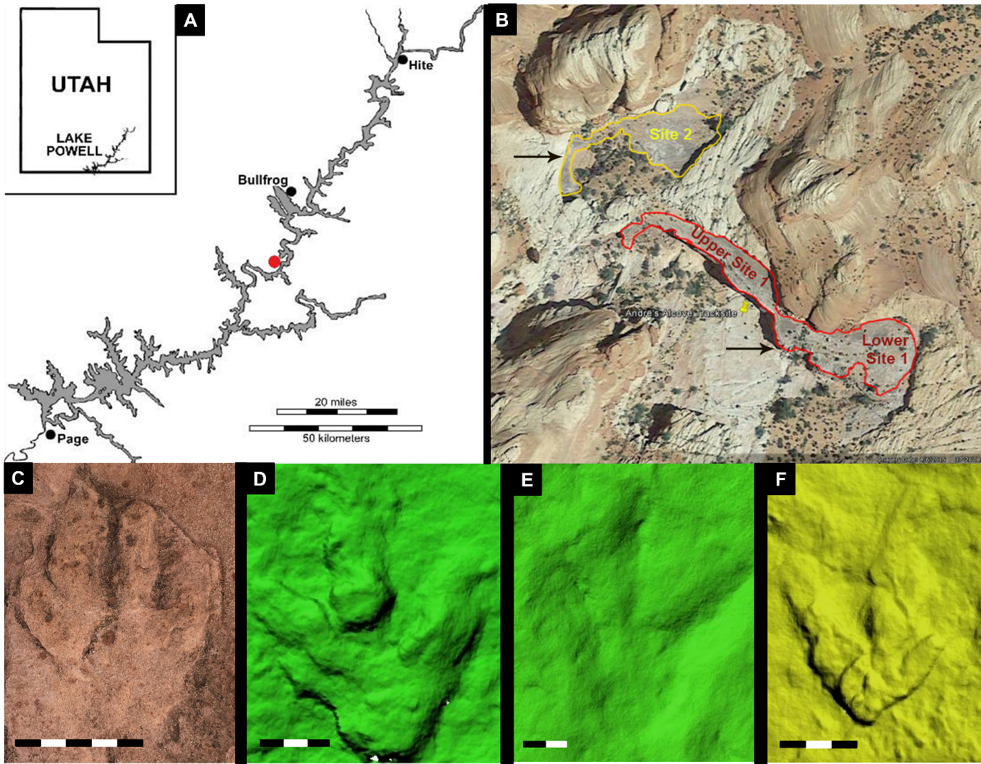
Introduction
The Lower Jurassic (?190–185 Mya) Navajo Sandstone Formation is a thick unit of primarily well-sorted, cross-bedded sandstones that has broad exposure across the American Southwest. This formation largely comprises of “petrified” eolian (wind deposited) dune sequences, with locally abundant interdunal carbonate deposits suggesting wet, oasis-like environments (Eisenberg, 2003; Loope & Rowe, 2003; Rainforth, 1997; Wilkens, 2008). One such deposit occurs stratigraphically low in the Navajo Sandstone at the Andre’s Alcove Dinosaur Tracksite (AAT) within the Glen Canyon National Recreation Area (GLCA), Utah. This site preserves a variety of tracks from Early Jurassic vertebrates, including both large and small theropod dinosaurs, small ornithischian dinosaurs, and early crocodylomorphs. A joint team from the National Park Service (NPS) and the St. George Dinosaur Discovery Site (SGDS) first documented the site in 2017. The AAT was originally discovered by commercial photographer Andre Delgalvis, who reported the site to the NPS the year before. Following fieldwork in 2017, another team from the NPS and SGDS returned to the site in 2018 to photo-document three tracksite areas on the same stratigraphic horizon at the AAT to create computerized 3-D photogrammetric models of each track surface area to potentially understand the surface features at the AAT.
The AAT is divided into three separate sites: Upper Site 1, Lower Site 1, and Site 2. These sites were differentiated according to available exposures of a single paleosurface that preserves the dinosaur tracks at the AAT. The most prevalent ichnotaxa (track type) identified thus far at the AAT are those of dinosaurs, including Eubrontes, made by large theropod dinosaurs; Grallator, made by smaller theropod dinosaurs; and Anomoepus, made by small ornithischian dinosaurs. Non-dinosaurian ichnotaxa identified thus far include Batrachopus, made by a protosuchian crocodyliform. Vertebrate body fossils are rare in the Navajo Sandstone, but small theropods (Camp, 1936; Carrano et al., 2005), sauropodomorph dinosaurs (Galton, 1971; Sertich & Loewen, 2010), and protosuchians (Galton, 1971; Rinehart et al., 2001) are known, so the ichnofaunal record at the AAT partially corresponds to the known Navajo fauna.
_and_examples_of_tracks_preserved_at_the_sit.png)
Geological Setting
The Navajo Sandstone, the uppermost formation of the Glen Canyon Group, is an enormous eolian sequence measuring ~750 m thick in southwestern Utah and ~165 m thick in north-central Arizona (Peterson & Pipiringos, 1979). Along Lake Powell, the Navajo measures about 365 m thick. The uppermost strata of the underlying Kayenta Formation (mostly playa deposits) grade conformably into the Navajo Sandstone. Within GLCA, the Kayenta Formation is very thin (~95 m) and sandy compared to silty–muddy facies to the south and west (Blakey, 1996). In the vicinity of Lake Powell, the Middle Jurassic Page Sandstone and Temple Cap Formation overlie the Navajo Sandstone at the J-1 unconformity (Peterson & Pipiringos, 1979).
The AAT is about 20–30 m above our proposed Kayenta–Navajo contact, but due to the COVID-19 pandemic, we have been unable to return and measure a stratigraphic section. The AAT horizons are composed of dark gray, coarse-grained, sandy dolostones about 5 m thick. These beds extend from the AAT laterally to the north for over a kilometer, and most exposures preserve vertebrate tracks. Smaller-scale carbonate beds up-section from the AAT are thinner, have a smaller surface areas, and taper laterally in cross-section. All carbonate beds lie between sand-dune sequences, and likely represent water pooling in topographic lows between dunes (i.e., interdune playas). Many such carbonate-rich beds within the Navajo Sandstone preserve microbial mats, and even large-scale stromatolites (Dorney & Parrish, 2009; Eisenberg, 2003), suggesting that some of these oases may have remained water-filled for several years. Water accumulation resulted from heavy monsoon seasons and/or water-table rise (Loope et al., 2001).
Materials and Methods
In 2018, AAT site surfaces were cleaned with brushes and brooms prior to field data collection, photography, and photogrammetric documentation using standard techniques (Lallensack et al., 2020). Photogrammetry (a method of producing 3-D digital images) of the track surfaces was processed via Agisoft Metashape Professional (v. 1.7). For the purposes of this study, both 3-D and digital elevation models (DEM) were made for each of the three AAT sites. The DEM were preferred in identification of tracks mentioned below, but both were used in order to better understand general surface features. In each model, track length and width measurements were taken using scale provided by control sticks in the photographs. For trackways, stride and pace were also calculated (Table 1).
Results
Upper Site 1
At current count, Upper Site 1 preserves 26 tracks, of which 23 pertain to Eubrontes; four of these comprise trackway AAT-S1U-01. The remaining three tracks pertain to Grallator and comprise trackway AAT-S1U-02.
Lower Site 1
At current count, Lower Site 1 preserves 15 tracks, of which 14 pertain to Eubrontes; five of these comprise trackway AAT-S1L-01. The remaining track is an isolated Grallator.
Site 2
At current count, Site 2 preserves 22 tracks, 15 of which pertain to Eubrontes; five of these pertain to Grallator (of which 3 potentially may comprise a trackway), and two pertain to Anomoepus. While identified visually at the AAT during the 2018 expedition, currently no Batrachopus tracks have been documented in the photogrammetric models.
Discussion
Many tracks at the AAT that were visually recognized in the field have yet to be documented in the photogrammetric models. Nevertheless, current data suggests that the AAT is a vertebrate tracksite of major paleontological significance. Eubrontes is currently the most abundant dinosaur ichnotaxon in the Navajo Sandstone (e.g., Lockley et al., 2021), though Grallator and, less commonly, Anomoepus, Otozoum, Navahopus, and Moyenisauropus also have been recognized at other tracksites (Hamblin & Bilbey, 1999; Hunt & Lucas, 2006; Lockley et al., 2021; Lockley & Gierliński, 2006, 2014; Milàn et al., 2008; Rainforth, 1997, 2003). Several non-dinosaurian ichnotaxa known from elsewhere in the Navajo Sandstone, such as Pteraichnus (Stokes & Madsen, 1979) and Brasilichnium (Lockley, 2011), also have not yet been recognized at the AAT. The AAT is unusual in the sheer number of diverse track types at a single site. However, no current evidence suggests organisms had interacted with one another at the AAT, so the tracks preserved were most likely made over an indeterminate span of time.
Why Eubrontes (large theropod dinosaur) tracks dominate at the AAT is unclear. No geological evidence is preserved that would suggest a paleoenvironmental reason that large carnivores would have congregated at this site. Possibly the reason is taphonomic: the larger size and greater weight of Eubrontes track makers enabled them to create deeper, more readily recognizable tracks than those of smaller, lighter track-makers. Further analysis of the site, and a fuller catalog of ichnotaxa and their relative abundances, may help clarify this issue.
Vertebrate tracksites are less abundant in the Navajo Sandstone than they are in underlying, earlier Jurassic formations. The AAT is one of the larger vertebrate tracksites in the Navajo Sandstone, and is itself a small exposure of a more extensive track surface. It thus expands the current understanding of vertebrate faunal dynamics during this underrepresented time period in western North America. Additionally, tracksites in younger, overlying strata preserve evidence of different track-making faunas. The AAT thus helps aids the understanding of Early–Middle Jurassic faunal evolution in western North America. Because this research is ongoing, and this report is preliminary, no conclusions can yet be drawn. However, the ichnofaunal similarity of the AAT to those of underlying formations suggests that major faunal turnover had not yet occurred.
Future Work
Successful completion of Agisoft Metashape surface models has provided the groundwork for beginning an in-depth study of the surface features at the AAT. More work is required to identify further, mostly smaller trackways and tracks (most notably Batrachopus) in the photogrammetric models. Additionally, further study of the rendered surface may reveal behavioral traits of the track-makers. Further sites to the north of the AAT also preserve tracks, including Navahopus, which will require documentation and possible photogrammetric modeling.
Acknowledgements
We thank Andre Delgalvis and his family for the discovery, reporting of the AAT to the NPS, and for field assistance. We also thank the National Park Service for extensive funding which assisted the 2017 and 2018 expeditions provided under NPS permit #GLCA-2018-SCI-0016, boats and resources, and assistance from NPS personnel, including John Spence, Maria Rodriguez, Vincent Santucci, and Jack Wood. Thanks to the St. George Dinosaur Discovery Site for resources and personnel who also assisted in the AAT documentation, notably David Slauf. Additionally, we thank Mike Frielinger, who supplied a houseboat and his assistance, and Mike Callahan, who also assisted in fieldwork on the 2018 AAT expedition. Dixie State University provided funding for this project via grant #18-T004; the DSU Earth and Environmental Sciences Department coordinated the installation of hardware necessary for running Metashape.